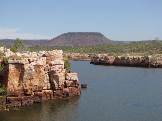
Berkeley River
Darwin to Broome – June to September
The Kimberley Coast, as the crow flies around the edge of it, is roughly 600 nautical miles long from Broome in Western Australia to the Northern Territory Border. Of course, it is vasty longer than this, encompassing inlets, rivers, bays and islands. The scenery can range from the spectacular to the mundane and you will find the water’s edge abutting mangroves, sandy beaches, muddy inlets and spectacular escarpments. The birdlife is prolific but you need time – and quiet – to enjoy it. Crocodiles are plenty, more prolific in some places than others. Sengo spent three months traveling from Darwin to Broome (7 June to 3 September), her crew taking in as much as they could, but three months is no where near enough time to experience all of this coast. Most of the land along the Kimberley Coast is Aboriginal land and you need permission to go to shore; in some cases you are restricted to specific locations and in other cases specific locations need a fee payed permit (with time limits). At this stage there are no restrictions on the time anchored in the water. We knew three months was never going to be enough time to see it all but we now have a taste and we have a list of things we missed that we hope we can get back to (including some iconic waterfalls – but we may just take a helicopter ride to see them (instead of slogging up rock strewn gorges)).
Travelling by personal craft means that, in the main, you can take your time. The big disadvantage of this, is that no matter how much information you read up on beforehand, you miss out on the interpretation guidance of experts that the commercial tour operators have access to.
Photographically, some of the Kimberley is spectacular but a camera never captures the true colours (and philosophically what are true colours anyway – we all see the world differently). That said, a professional photographer would get a great portfolio spending time here. I am not a professional photographer. And I don’t have professional cameras. Add to this most of my photographs for the journey were taken whist I was on board a moving or rocking boat. To try to counter shake I had the automatic settings mostly on the ‘sports’ function. The downside of this of course is that you lose focal length (needed for landscape photographs) and the ability to manipulate the settings. As a result, photographs for the Darwin to Broome trip may not be in perfect focus… but you will get the idea. A selection of photographs is at the end of this post.
Our anchorages for the journey are listed below as well as the birds we identified along the way. Also listed are the commercial tourist boats we came across in our journey (just in case you are interested in taking in the Kimberley the luxurious way). I suspect it was probably a result of us leaving so late in the season but we only saw around a dozen private vessels.
Aboard Sengo newsletters for June, July and August will be published separately.
Anchorages
The following table lists the ‘approximate’ location of where we anchored during our three month journey. Some anchorages were prettier than others and quite a few were just overnight stops as part of an ongoing journey. (Note: We take no responsibility for the safety of any vessel or individual that tries to anchor in the same locations as those listed below).
| Location | Latitude | longitude |
| Blaze Point | Not recorded | |
| Anson Bay | 13°26′.551S | 130°04′.039E |
| Port Keats | 14°07′.884S | 129°32.828E |
| Yelche Beach | 14°18′.699S | 129°23′.229E |
| Reverley Island | 14°22′.018S | 127°48′.255E |
| Berkeley River 1 | 14°28′.402S | 127°41′.327E |
| Berkeley River 2 | 14°23′.405S | 127°43′.838E |
| Berkeley River 3 | 14°21′.740S | 127°45′.786E |
| Seaplane Bay | 14°06′.064S | 127°32′.312E |
| Kalooma Bay | 13°56′.403S | 127°19′.964E |
| King George River 1 | 14°02′.280S | 127°19′.623E |
| King George River 2 | 14°00′.798S | 127°21′.225E |
| King George River 3 | 13°58′.905S | 127°21′.705E |
| Glycosmis Bay 1 | 13°53′.411S | 127°04′.978E |
| Glycosmis Bay 2 (inner) | 13°54′.361S | 127°03′.768E |
| Jims Bay | 13°46′.486S | 126°59′.614E |
| Cape Talbot | 13°48′.543S | 126°45′.397E |
| Mission Bay 1 | 14°06′.687S | 126°41′.466E |
| Mission Bay 2 | 14°06′.919S | 126°42′.600E |
| Honeymoon Bay | 14°05′. 922S | 126°40′.959E |
| Governor Islands | 13°57′.521S | 126°41′.144E |
| Sir Graham Moore Island | 13°54′.303S | 126°32′.927E |
| Jar Island | 14°0’9.324S | 126°13′.699E |
| Freshwater Bay | 14°00′.768S | 126°10′.965E |
| Parry Harbour | 13°58′.826S | 126°04′.396E |
| Osborne Islands area | 14°21′.016S | 126°03′.499E |
| Mitchell River 1 | 14°34′.005S | 125°40′.532E |
| Mitchell River 2 | 14°37′.400S | 125°39′.700E |
| Wollaston Island | Not recorded | |
| Palm Island | 14°34′.050S | 125°25′.897E |
| Swift Bay E | 14°31′.336S | 125°35′.800E |
| Swift Bay W | 14°32′.004S | 125°33′.197E |
| Bigge Island 1 Wary Bay | 14°27′.903S | 125°08′.734E |
| Bigge Island 2 South | 14°38′.597S | 125°07′.527E |
| Hunter River -Porosus Creek 1 | 15°00′.440S | 125°24′.728E |
| Hunter River | 14°59′.256S | 125°29′.342E |
| Hunter River- Porosus Creek 2 | 14°59′.116S | 125°24′.591E |
| Careening Bay | 15°06′.185S | 125°00′.312E |
| Hanover Inlet | 15°19′.133S | 124°46′.427E |
| Sheep Island | 15°29′.704S | 124°36′.969E |
| Sampson Inlet | 15°29′.861S | 124°29′.501E |
| Deception Bay | 15°38′.924S | 124°26′.112E |
| Red Cone Creek | 16°06′.609S | 124°36′.910E |
| Raft Point | 16°04′.529S | 124°27′.498E |
| Montgomery Reef | 15°58′.334S | 124°16′.965E |
| Melomys Island | 16°09′.571S | 124°04′.242E |
| Dugong Bay 1 | 16°24′.539S | 123°53′.610E |
| Dugong Bay 2 | 16°23′.462S | 123°53′.444E |
| Dugong Bay 3 | 16°22′.498S | 123°51′.303E |
| Horizontal Falls | 16°22′.235S | 123°58′.361E |
| Talbot Creek | 16°18′.386S | 123°47′.718E |
| Silver Gull Creek | 16°09′.889S | 123°42′.291E |
| Coppermine Creek | 16°12′.535S | 123°36′.611E |
| Dunvert Island | 16°16′.898S | 123°31′.809E |
| The Graveyard | 16°21′.271S | 123°41′.011E |
| Crawford Bay | 16°29′.709S | 123°29′.336E |
| Catamaran Bay | 16°27’.532S | 123°00′.891E |
| Cape Leveque | 16°23′.033S | 122°57′.443E |
| Beagle Bay | 16°54′.507S | 122°29′.752E |
| Broome |
Commercial Tourist Operators
Apart from one notable exception, all interaction with commercial tourist operators has been terrific, some crew quite inquisitive, and all friendly. Listed below are the commercial tourist operators we came across during our three-month journey. Each has its own appeal (and its own price tag!).
True North – http://www.truenorth.com.au
Ocean Dream – www. oceandreamcharters.com.au
Eco Abrolhos – http://www.ecoabrolhos.com.au
Great Escape -www.greatescape.net.au
Caledonia Sky – http://www.aptouring.com.au
L’ Austral – http://www.ultimatecruising.com.au
Kimberley Quest II – http://www.kimberleyquest.com.au
Lady M – http://www.ladymcruising.com
Coral Discoverer – http://www.coralexpeditions.com
Kimberley Explorer – http://www.kimberleycruise.com.au
Diversity Charters -www.diversitycharters.com.au
Reef Prince – http://www.kimberleyexpeditions.com.au/reef-prince
Other paces of interest…
Honeymoon Bay Campground – phone (08) 9161 4378
Horizontal Falls Seaplane Adventures–www.horizontalfallsadventures.com.au
Cygnet Bay Pearl Farm – www.cygnetbaypearlfarm.com.au
Cape Leveque – http://www.kooljaman.com.au
The Bird list
Whilst we weren’t on a ‘bird watching tour,’ we did however take the binoculars just about everywhere we went. Of course we saw many more birds than we actually identified and on some days I’ve listed our daily bird list, whilst on other days I haven’t listed any at all. The list that covers the entire trip is below (they are in no particular order)..
- Brown booby
- Darter
- Pied cormorant
- Least frigatebird
- Great billed heron
- White faced heron
- Great egret
- Intermediate egret
- Eastern reef egret
- Striated heron
- White ibis
- Pacific black duck
- Osprey
- Black kite
- Brahminy kite
- Whistling kite
- Collared sparrowhawk
- White bellied sea eagle
- Wedge tailed eagle
- Peregrine falcon
- Orange footed scrub fowl
- Buff banded rail
- Brolga
- Beach curlew
- Pied oyster catcher
- Sooty oyster catcher
- Masked lapwing
- Mongolian plover
- Oriental plover
- Red capped plover (dotterel)
- Black winged/pied stilt
- Ruddy turnstone
- Eastern curlew
- Common sandpiper
- Curlew sandpiper
- Emerald ground dove
- Peaceful dove
- Bar shouldered dove
- Common bronze wing pigeon
- White quilled rock pigeon
- Red tailed black cockatoo
- Sulphur crested cockatoo
- Red winged parrot
- Sacred kingfisher
- Collard kingfishers
- Rainbow bee eater
- Black faced cuckoo shrike
- Mangrove robin
- Sandstone shrike thrush
- WiIly wagtail
- Purple crowned fariy wren
- Little Friarbird
- Singing honeyeater
- Brown honeyeater
- Mistletoe bird
- Red browed pardalote
- Yellow oriole
- Great bowerbird
- Pied butcherbird
- Toresian crow
- Channel billed cuckoo
- Diamond dove
- Double barred finch
- Chestnut fronted manikin
- Broad billed flycatcher
- Rufous whistler
- Mangrove gerygone
- White gaped honeyeater
- Red backed wren
- Red collared lorikeet
- Little shrike thrush
- Silver Gull
- Common bronze wing pigeon
- White quilled rock pigeon
- Red tailed black cockatoo
- Sulphur crested cockatoo


 Trish Ebert 61 427 813 547")
 Trish Ebert 61 427 813 547")
 Trish Ebert 61 427 813 547")
 Trish Ebert 61 427 813 547")


 Trish Ebert 61 427 813 547")
 Trish Ebert 61 427 813 547")
 Trish Ebert 61 427 813 547")
 Trish Ebert 61 427 813 547 Berey River")
 Trish Ebert 61 427 813 547")
 Trish Ebert 61 427 813 547")
 Trish Ebert 61 427 813 547")
 Trish Ebert 61 427 813 547")
 Trish Ebert 61 427 813 547")
 Trish Ebert 61 427 813 547")
 Trish Ebert 61 427 813 547")
 Trish Ebert 61 427 813 547")
 Trish Ebert 61 427 813 547")
 Trish Ebert 61 427 813 547")
 Trish Ebert 61 427 813 547")
 Trish Ebert 61 427 813 547")

 Trish Ebert 61 427 813 547")


 Trish Ebert 61 427 813 547")


 Trish Ebert 61 427 813 547")


 Trish Ebert 61 427 813 54")

 Trish Ebert 61 427 813 54")
 Trish Ebert 61 427 813 54")
 Trish Ebert 61 427 813 54")
 Trish Ebert 61 427 813 54")
 Trish Ebert 61 427 813 54")
 Trish Ebert 61 427 813 54")
 Trish Ebert 61 427 813 54")
 Trish Ebert 61 427 813 54")
 Trish Ebert 61 427 813 54")

Great set of images and impressive list of birds, guys!
Thanks Chris. The birds were frustrating – you can hear so many – you just can’t see them! On the outer reaches there were lots of terns but as yet I am unable to differentiate most of them. Hopefully by the time we get down south I will be better at it – they all seem to have the same amount of black on their heads!
With terns, look at the colour of the beak and feet, as well as the feathers on their head😊
Thanks Chris, I will try – though not aways easy when sailing at speed in bumpy seas. Apologies in the delay for replying -we have been out of range between Broome and Dampier. Cheers Trish
Looks wonderful. Is the operator who was ‘the exception’ to the nice, helpful type in your list, or did you leave them off? Lol.
Hi Sue. Yes, I can see how that would be tempting. However, to be fair – the exception to the rule is in the list – I detail the incident/s in August’s newsletter. Cheers Trish